Even the most experienced traveler can become disoriented in an unfamiliar place. Moreover, fatigue, bad weather, incomplete visibility can play a cruel joke on a tourist even on a simple and explored route. If you do not want to become a hero of the sad news about the mysterious disappearance of a tourist, we advise you to take a special navigator with you on the road. This device will help pave the way to the desired goal and find the way back.
So that you can easily choose the most functional product, the editors of the site "bestx.htgetrid.com/en/" prepared a rating of the best tourist GPS navigators for 2020.
Content
Selection features
Most modern goods have a number of additional functions. The optimal device, which is indispensable for a hike, will have the following options.
Location
A modern navigator should easily determine your current geolocation. The speed and correctness of this option is influenced by the tracker's sensitivity to signals and the type of satellite with which the device works. There are mainly two satellite systems used: GPS and GLONASS. Both of these satellites work well, but they are characterized by errors depending on the latitude in which the user is located. We recommend purchasing combined navigators, so they can work more correctly.
Resistant to adverse weather conditions
Hiking and travel is often associated with extreme conditions, so the device must withstand sudden changes in pressure and temperature, be waterproof and not afraid of cold and damp. The case must be shockproof so as not to be damaged if dropped.
Battery life
Agree, a discharged device at the most inopportune moment can significantly disrupt plans and ruin your rest. To avoid such unpleasant surprises, take into account the peculiarities of the battery of your navigator.
If it's a battery, be sure to carry a power bank and a spare battery with you. If these are batteries, you should also provide for the presence of spare batteries. Remember that a quality product should last 2-3 days. Otherwise, you are drawing to carry a bunch of chargers and batteries with you, making your backpack heavier.
It is these characteristics that distinguish the navigator from a similar application in a smartphone. A phone or a similar gadget, due to the presence of additional services and programs, can quickly discharge and even freeze. The tracker in the form of a separate device will last much longer, and it also works more correctly.
Device types
In total, there are several types of similar goods:
- The tracker is the most primitive product, it is able to record the user's movements, remembering the entire path. Thus, the traveler will not get lost, easily finding the way back. If you wish, you can mark the place you like. It is not possible to download custom trackers. This is the cheapest option.
- Navigator without map support - it can record the user's path, but you will not be able to download your maps to the device.It is possible to plan a route in advance. This will allow you to think through all the subtleties of travel to the smallest detail. The product can be equipped with a map loaded by the manufacturer, but you cannot add new ones. Such a product is needed rather as a safety net, it will not allow you to get lost in the event of a sharp deterioration in weather conditions. However, we recommend that you carry a compass with you.
- Navigators with map downloads - if you are an active traveler and often visit places and areas that require special attention, this is the ideal device for you. These models are equipped with detailed maps, but the user can download any other. Loading information will not raise questions for most users. Also, the navigator can support a wireless Internet connection, so you can get additional routes on the spot. This content may be provided free of charge or may require payment. In this case, everything depends solely on the financial capabilities and needs of the user.
On the market you can find products that provide imagery from space for an optimal assessment of terrain and landscape. Often this feature is only available with a user subscription.
Control method
Such products differ not only in functionality, but also in the management system. This point does not carry any semantic load, it rather affects the personal preferences of the user.
- Sensor system - everything is simple here: the product works like any smartphone. However, there are small nuances. There are models that respond only to the touch of bare fingers. And there are products that can react to gloved hands. It is worth noting the fact that the sensor responds poorly at low temperatures, so take into account the conditions of the area in which you plan to use the navigator.
- Mechanical system - the most reliable options are represented by product buttons. They work quickly in extreme conditions, do not freeze and do not refuse control. The buttons will not break even if the device is dropped and the screen is broken.
Additional equipment
Like all equipment, navigators are equipped with a number of secondary options, the need for which is determined by the user. All these functions are undoubtedly useful, but even without them the device will function quite correctly. So how can a manufacturer improve their product?
- Signal reception sensitivity - most options for better signal pickup in hard-to-reach places (dense dense forest, mountains, cave) are equipped with an antenna. Such devices are quite bulky but reliable. Modern models do not have an antenna, but they are also equipped with a receiver for more accurate signal pickup. There is not much difference between these products.
- Processor performance - is responsible for the performance of the navigator services. The more powerful the device, the sooner it will react to actions from the user. You can determine the indicator of this option by carefully studying the instructions. However, keep in mind that a powerful processor will drain the battery faster.
- Storage capacity - most often, the amount of storage in your navigator allows you to store many maps and routes. And if this is not enough for you, you can always additionally purchase a USB flash drive, a connector for it is available in all modern models.
- Reflective screen - the monitor of modern equipment is processed with a special material that allows you to read all the information in strong light conditions. Thus, the user does not have to go into the settings and adjust the brightness once again.
- Compass - they come in different types. But if you have an analog version of the compass, then you have nothing to pay extra for having this add-on in your device.
- Barometer - allows you to assess weather conditions, as well as predict their change. Thanks to this, you will be maximally prepared for any surprises during your trip. And the barometer also allows you to determine the height if the action takes place in the mountains.
- Camera - of course, you won't be able to get a high-quality picture, but you can easily remember the area you like, tie it to the map, having precisely determined the required coordinates.
- Wireless data transmission - directly related to the above function. With this function, you can upload a photo to another device. If you wish, you can synchronize several gadgets, so the transfer of information will occur automatically.
- Mounts - if your journey will be accompanied by a ride on a bike or bicycle, you cannot do without a special safety lock.
Advice! Remember that there are currently products that can track people. They are prohibited for sale and use. Travel navigators in most cases are not capable of such a function, but do not forget to make sure that the purchase of the gadget is legal before buying.
Rating of the best GPS navigators and trackers for 2020
Garmin Montana 680
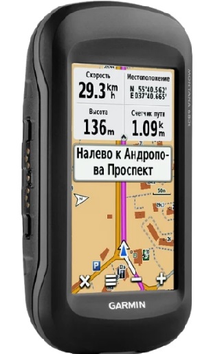
The compact and efficient device has long earned the trust of both professional and novice tourists. Despite the small screen, the image obtained on it is convenient for studying. The high pixel density allows you to carefully examine the maps and terrain.
The control system is touch-sensitive, it works even when pressed with gloved fingers. The battery is designed for 16 hours of uninterrupted operation. It is also possible to install two batteries. If desired, the user can easily replenish energy by recharging in the car. The navigator supports all satellite systems, the details of the maps deserve a separate mention. The landscape is drawn accurately, the description indicates the type of forest, only relevant and verified information is used. Catching the signal will not be difficult, in addition, the possibility of loading custom maps is provided.
The body of the product is made of shock-resistant materials that are not afraid of getting into water. A separate and significant advantage will be the presence of a good camera that allows you to take a high-quality picture and instantly link it to coordinates.
Advantages:
- versatility of food;
- high-quality assembly;
- perfectly catches the signal;
- waterproofness;
- the ability to download your own maps;
- works with GLONASS AND GPS.
Disadvantages:
- high price;
- paid content.
The average cost is 50,000 Russian rubles.
Garmin GPSMAP 64ST
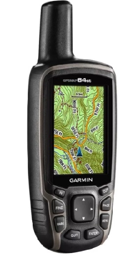
And one more representative of the brand described above. It is ideal for hikes and long walks in unfamiliar tourist areas. The body is made of rubberized materials, which, coupled with the convenient shape of the device, allows you to easily carry the navigator in your hand for a long time. Also, you can not be afraid to drop the gadget into the water, a short contact with moisture will not harm the product.
Fans of simple control will appreciate the device at its true worth - instead of complex sensor systems, the model is made in a push-button version. The small screen does an excellent job with its functions, it is possible to work with custom maps, additional services. The user can synchronize the gadget with his smartphone via a Bluetooth connection. Thus, you can duplicate the information you need or send it to another tourist. The antenna sensitivity is high, and there is a built-in accurate compass. In addition, the manufacturer has equipped the product with a barometer, which will make it easy to find out any changes in the weather.
Advantages:
- strong body;
- multifunctionality;
- built-in barometer and compass;
- sensitivity.
Disadvantages:
- weak processor;
- not compatible with all smartphones.
The average cost is 20,000 Russian rubles.
Garmin eTrex 20x
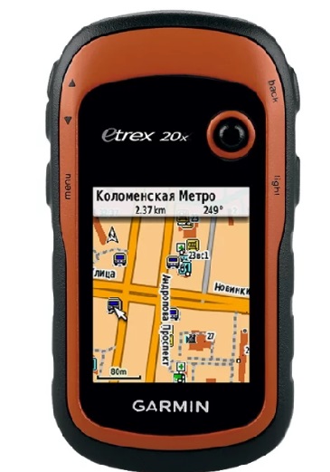
If the two options described above have attracted you with their performance, but scared you by the price category, then we advise you to take a closer look at the budget and high-quality model.
This option is a completely redesigned legacy version. The screen and the volume of the drive have undergone modernizations. Also attractive is the protective and compact body.The device provides conventional maps, road and sea routes. It is possible to install your own maps and trackers.
The navigator is powered by batteries, the autonomy is calculated for 25 hours of continuous work. However, there are also weaknesses. First, it's a small, albeit improved display. Secondly, a weak processor that causes slight freezes of the device.
Advantages:
- a budget option;
- versatility;
- high-quality assembly;
- waterproofness;
- sensitivity.
Disadvantages:
- small screen;
- weak processor.
The average cost is 13,500 Russian rubles.
Avel DRC050G
This product is made in China, its quality is somewhat lower than that of the brand in the ranking above. However, this is a good version for those who want to save money without losing the quality of the product.
The screen is touch-sensitive, it responds correctly to pressing hands with gloves. Power is supplied by a battery that can be charged in the vehicle. There is a dust protection, which will ensure the safety of the navigator in conditions of fast riding on a motorcycle or bicycle. The screen is relatively wide, its brightness is sufficient for comfortable use. The "stuffing" of the equipment is standard for Chinese goods, the amount of memory, although small, is enough for additional software. The user has the ability to upload his maps. And we strongly advise you to do this, since the established information will allow you to study only highways.
Advantages:
- acceptable price;
- dust protection;
- durable body;
- capacious battery.
Disadvantages:
- no topographic maps in memory;
- small amount of storage.
The average cost is 7,000 Russian rubles.
Delorme inReach Explorer
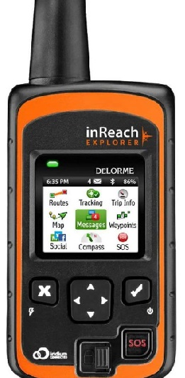
Such a device will become an indispensable assistant for an experienced tourist at any time of the year. First of all, what will attract an avid traveler is the opportunity to compile a detailed report on your movements. The navigator takes into account the distance traveled by the user and the time spent on the trip. The built-in compass and barometer will also be a big plus, they will not let you lose orientation and will allow you to prepare for any weather surprises.
Despite the compactness of the gadget, it has a relatively large and bright screen and a comfortable virtual keyboard.
Advantages:
- registration of speed, time and mileage of movements;
- compass and barometer;
- accuracy;
- small size.
Disadvantages:
- absent.
The average cost is 25,000 Russian rubles.
Spot gen3
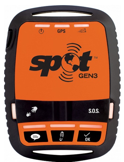
If you are planning an extreme vacation associated with a risk to life, you cannot do without such a device. The navigator is able not only to accurately establish the location and determine the coordinates. The gadget is equipped with an SOS signal in case of an emergency. The distress signal is sent through three channels: to the local rescue service, close friends and relatives (up to 10 trusted numbers) and a tourist or rescue team.
As for the technical specifications, they are also composed with the mind. A bright screen, performance, a capacious battery and sensitive antennas - all this will make this product an excellent assistant on the route.
Advantages:
- distress signal;
- high-quality assembly;
- acceptable price.
Disadvantages:
- no significant disadvantages have been identified.
The average cost is 19,000 Russian rubles.
If you had experience using the products described in the rating, write your feedback in the comments.


 for 2020")


